Leatherhead & District Local History Society
Early photos of the development of Bookham

Roy Mellick, Records Secretary & Bookham Archivist for the Leatherhead & District Local History Society writes: Have you ever wondered what Bookham must have looked like at the beginning of the 20th century when the population was just a few thousand?

Well for some of you this question will have been answered when several large (83.5 x 58.5cm) photographs were displayed inside the Old Barn Hall on Bookham's Village Day, 2012.

These photographs show mostly the South side of the village from The Ridgeway to the Effingham crossroads and include Blackthorne Road, Chalk Pit Lane, Crabtree Lane, Dowlans Road, Howard Road, Hale Pit Road, Dorking Road, Dawnay Road, Oakdene Road, Woodlands Road and the Guildford/Leatherhead Road. Unfortunately, no pictures of the High Street or to the North side of the village are included apart from Eastwick Road, Keswick Road and The Ridgeway.

Most side roads were deeply rutted cart tracks and only the main roads were made up. Getting around the village in the winter or after long periods of bad weather would have been challenging and messy. Many of the houses shown still exist today but generally with much reduced back gardens as in-filling became the norm and land became scarce. Today there is little room for expansion as the population creeps closer
to 12,000. It was around 4,000 in the 1920s and 1930s.

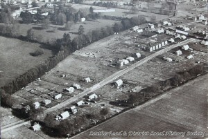
Why were the photographs taken? The reasons are uncertain but most likely this was the application by the Council of newly acquired skills, learnt during the 1914-18 war surveying battlefields from the air. The date when the pictures were taken is not given but two sources have confirmed the most likely date as around 1922 or 1923.

Thanks must go to Jack Straw, Head of Planning Policy, at Mole Valley District Council for allowing these photographs to be shown and having the foresight to donate them to the Leatherhead & District Local History Society for future safekeeping.

The images below are not actual size.

A CD with all seven full size digital high resolution images is available for £5 plus £1 postage by mail from the Leatherhead Museum: Leatherhead Museum, 64 Church Street, Leatherhead, KT22 8DP. Cheques should be made payable to Leatherhead and District Local History Society
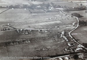
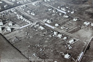
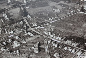
Crossroads Crabtree Lane/Eastwick Road/A246 & Downs Way
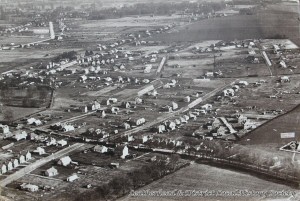
Woodlands Avenue/Guildford Road (A246)/Chalkpit Lane

Dorking Road/Howard Road/Dawnay Road/A246/Crabtree Lane

Dowlans Road/Dorking Road/Howard Road/Dawnay Road/Ridgeway

Downs Way/Halepit Road


Dowlans Road/Dorking Road/Chrystie Recreation Ground.

Crabtree Lane/Howard Road/Dawnay Road/Oakdene Close
 

İLeatherhead & District Local History Society 2012
last updated 19 Nov 12